A personal history of Huron FSS written and submitted by Jim Anez, Huron Flight Service Station
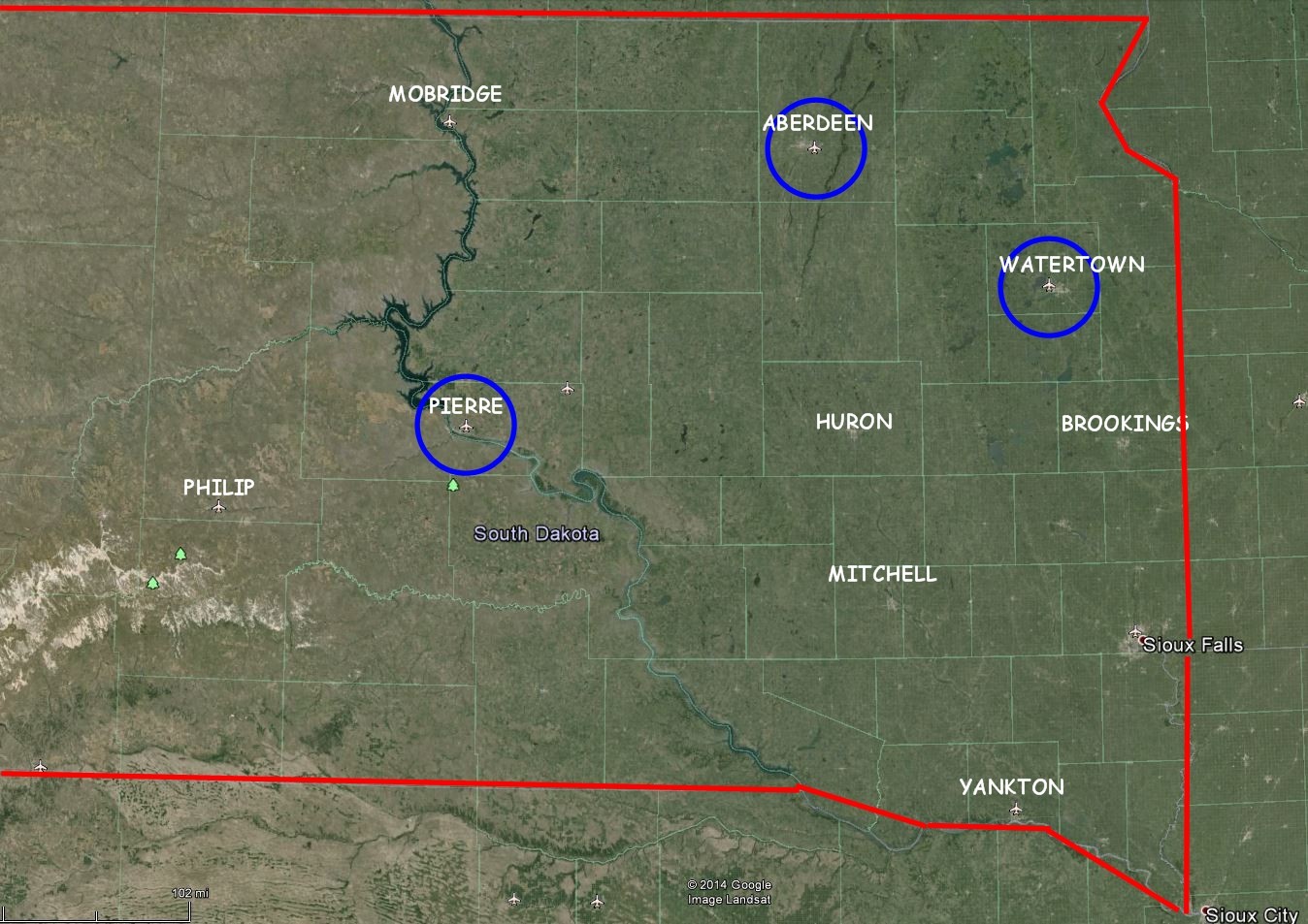
I went from the manager’s position at Pierre FSS to Huron AFSS as Plans and Procedures specialist (PPS). I was one of 3 staff specialist (the others being Training and Quality Assurance) who established many of the procedures as the facility became fully automated. In 1994 I went back to the controller work force because I was 3 years short of time required to be eligible for retirement at age 50. When I did this the other specialists indicated they wanted me to be the union Facility Rep so I joined NAATS and was elected as facrep. When my term as NAATS rep was up, and I had my “good time” in, management asked if I would consider moving back into a staff job. I agreed without thinking that the job title was now “Support Specialist”, it was the only staff position, and it encompassed the duties of the PPS, Training and Quality Assurance (QA). It worked out well, I liked the work, and one of my proudest moments was in 2000 when the facility received a perfect score on a full facility evaluation. I retired in November 2001 and moved to Washington State. The Huron AFSS flight plan area in 1991 was all of South Dakota except for the Aberdeen, Pierre, Rapid City and Watertown airports. By 1994 the facilities at other airports were closed and Huron was responsible for the all airports in the state.
AIRCRAFT LOST, CONFUSED, IN DISTRESS OR WORSE?
This guy was REALLY lost
I came into work one evening at 2200. During shift turnover I noted that we had a Cessna 150 on a VFR flight plan due shortly at Custer, SD in the southern Black Hills. Not much later the pilot called on the Rapid City VOR to advise he was on the ground Custer and we closed his flight plan. The other specialist and I had a short discussion about the call because we weren’t really aware that we could talk to aircraft on the ground at Custer… but he’d called us, so we decided it was just “one of those things”.
Then we got a call from the pilot’s wife. She advised that she was at Custer and wondered about her husband’s ETA. We advised that he’d just landed. She said that she had been at the airport for a while and for sure no one had landed.
Before we had time to digest that the pilot called on the radio to say there was no one around and he was supposed to meet his wife. We told him she’d called and was at the airport. He assured us there wasn’t a soul around and it’s now past sunset and getting dark. We still couldn’t understand how he was talking to us from the ground in Custer, but since he was we asked him to give us his bearing off the Rapid City VOR. When we laid this out on the chart the line ran directly over the Custer airport and there were no other airports anywhere near that bearing.
Since it was obvious he wasn’t at Custer, but had landed on a paved runway that wasn’t charted, we were stumped. We asked him to look through the buildings and see if he could find anything to identify where he was. He found some boxes with a name and address on them. We somehow got a phone number for that person, in Nebraska, but that she knew nothing about airports in South Dakota and couldn’t even understand why a package with their name on it would be in the Black Hills. Meanwhile the pilot reported that he could see a north-south highway with a fair amount of traffic to the east below him. This sounded like US93 and confirmed that he was on the east side of the Black Hills somewhere – but didn’t help much.
Fortunately it was a pleasant summer night so we didn’t have to worry about the pilot’s well-being but he was concerned about the aircraft battery. We arranged for him to call every 30 minutes while we tried to puzzle out his location. I called the sheriff’s office to see if they knew of any paved private airstrips in the general area on the east side of the Hills west of highway US93. They advised there was a quarry in that area but there were no landing strips, especially paved ones.
The next time the pilot called we asked if there were any tractors or trucks around, thinking that if it was the quarry there should be some equipment. “Oh yeah,” he says “there are all kinds of trucks”. So we asked him to get a license plate number, which we then passed on to the sheriff’s office and they called the owner.
It turned out that there was a 500’ paved runway for radio control aircraft at the quarry site and that’s where our pilot had landed. We asked the sheriff if they would go out and rescue the guy, and that was the last I heard about the event.
I wasn’t there for this one, just heard about it and presume it’s true
A specialist was working with a pilot who was uncertain of his position. He was fairly close, but for some reason they weren’t having any luck with NAVAIDS. The specialist asked the pilot if he saw any railroads, highways, lakes or rivers. Yeah, he said he saw a road and he was following it. The specialist asked did the pilot see any signs. Yeah, he saw a sign. The specialist asked if he could tell what it said. Sure, the pilot says, the signs say “Do Not Litter!”
Navigation problem or pilot problem
A student pilot enroute from Sioux Falls to Huron (Sioux Falls is about 80 miles SE of Huron) became overdue. This was pretty much the middle of our flight plan area so we started checking airports and calling for him on all frequencies. He finally answered on the Flight Watch frequency and I think we concluded he was about 100NM WSW of Huron. Using our directional finder (DF) and pilotage we got him headed in the right direction and he finally landed. In discussing the situation it sounded like his directional gyro wasn’t working right but we couldn’t understand how he could be so far off course, and so far away and not know he was lost.
So, because it seemed like he had a hard time holding a heading we suggested that he should watch for the interstate highways to make sure he didn’t miss Sioux Falls. I-90 runs E-W through Sioux Falls and I-29 runs N-S through Sioux Falls. So we told him to turn south if he crossed the N-S interstate and turn east if he encountered an E-W interstate.
Again he came up overdue so we started looking for him and found that he had landed at Yankton, SD – 40 miles SW of Sioux Falls and 45 miles south of the interstate!
Off planned route
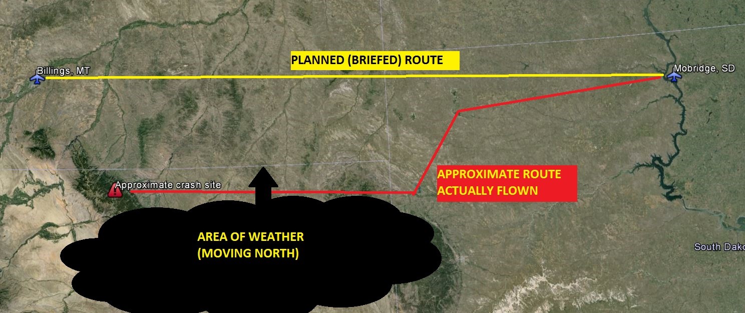
I was working a pilot briefing position one afternoon and took a call from a pilot in Mobridge who was planning a flight to Billings. There was poor flying weather forecast south of his route but based on his planned departure time it looked like he should get to Billings well before the weather moved across his route of flight.
It so happened that I had rotated to the radio position by the time he called to activate his flight plan so I talked to him again when he departed. A short time after the activation he called again to advise that he’d returned to Mobridge because a door had popped open. His final call, not too much later, was to advise he was again airborne and reactivated his flight plan.
 As the afternoon became evening we received a notification from Great Falls AFSS that the aircraft hadn’t arrived in Billings. The flight became overdue and search and rescue procedures were implemented. Eventually the aircraft wreckage was located on the east slopes of the Big Horn Mountains in northern Wyoming which was well south of the planned route. The aircraft had gotten into an area of restricted visibility after dark and flown directly into the mountain. Investigators were at a loss to understand why he was so far south but radar data was retrieved and it appeared that the pilot had intentionally flown west southwest after departure possibly to do some sightseeing.